|
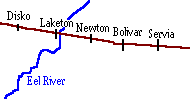
Erie Lackawanna - Wabash County, Indiana |
|||||||||||||||
|
|||||||||||||||
|
Erie Lackawanna - Wabash County, Indiana |
|||||||||||||||
|
|||||||||||||||
 |
 |
|
|
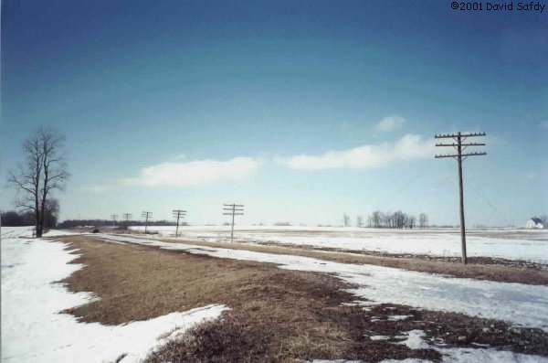
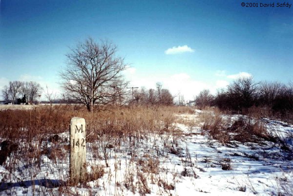
Single track ran through Servia. At one time there were several industries served in this area. Today, not much remains of the EL main line. Some sort of chemical company now occupies part of the mainline today. Two miles east of Servia at County Road 500E this is looking westward where telegraph poles dot the northern edge of the right of way. (41K photo) Milepost M142 resides just west of Servia. This is looking east. There will be no more trains passing this marker. (71K photo) Both photos taken 1/25/01. |
 At
Bolivar we are looking east from the State Road 13 bridge.
This is the Heritage Railroad and was actually a rebirth of the Erie Lackawanna
mainline in 1991. The line is rarely used today. At
Bolivar we are looking east from the State Road 13 bridge.
This is the Heritage Railroad and was actually a rebirth of the Erie Lackawanna
mainline in 1991. The line is rarely used today. |
 Looking
west towards Newton and Laketon from the SR 13 bridge where you can see
a small portion of double track. Looking
west towards Newton and Laketon from the SR 13 bridge where you can see
a small portion of double track.
|
 At Newton, where the PRR
line from Logansport to Butler crossed, little is left today. Small remnants of
the tower foundation are barely visible and the PRR ROW is slowly disappearing
into the trees. I talked with my girlfriends grandmother and she told me of the
days when she was in high school in nearby North Manchester. The father of a
friend of hers was a tower operator at Newton and they would frequently go down
to the tower after school and help her father out by throwing signals and
handing orders to crews as they passed. She remembers the old EL very vividly,
practically growing up on this piece of railroad and seeing it abandoned,
dismantled and forgotten by most. At Newton, where the PRR
line from Logansport to Butler crossed, little is left today. Small remnants of
the tower foundation are barely visible and the PRR ROW is slowly disappearing
into the trees. I talked with my girlfriends grandmother and she told me of the
days when she was in high school in nearby North Manchester. The father of a
friend of hers was a tower operator at Newton and they would frequently go down
to the tower after school and help her father out by throwing signals and
handing orders to crews as they passed. She remembers the old EL very vividly,
practically growing up on this piece of railroad and seeing it abandoned,
dismantled and forgotten by most. |
|
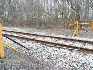 Apparently someone
decided to put a piece of pipe with a chain through it across the tracks leading
to the Laketon Refinery at one point. Did they REALLY think this would
stop a 200 ton locomotive? After closer inspection the chain links were
stretched and smashed severely and the steel pipe was pinched shut and bent in a
90 degree angle in the middle. So much for keeping NS out. Apparently someone
decided to put a piece of pipe with a chain through it across the tracks leading
to the Laketon Refinery at one point. Did they REALLY think this would
stop a 200 ton locomotive? After closer inspection the chain links were
stretched and smashed severely and the steel pipe was pinched shut and bent in a
90 degree angle in the middle. So much for keeping NS out. |
 At
Laketon, Indiana this is looking eastward from atop the mainline.
The Laketon Refining Corporation uses the right-of-way for routing their
pipes to and from the storage tanks. This location used to be a steel
bridge that crossed over this road (CR 1000N). I remember seeing
this bridge intact in 1986. At
Laketon, Indiana this is looking eastward from atop the mainline.
The Laketon Refining Corporation uses the right-of-way for routing their
pipes to and from the storage tanks. This location used to be a steel
bridge that crossed over this road (CR 1000N). I remember seeing
this bridge intact in 1986. |
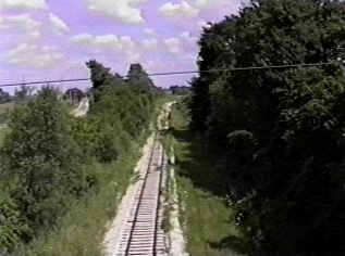
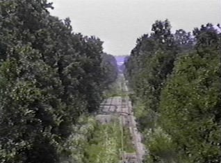
About a mile west of Laketon are the remains of RX Round Lake interlocking. This is where the single track began eastward towards WO interlocking, near Bippus. When the corn fields are empty in the Winter you can see this tall signal bridge for several miles. Looking east down the main at RX. The double track terminated just past the signal bridge. If you look carefully to the left of the signal bridge in the distance you can see the searchlight signal for westbound trains is still standing, as well. Where once fast freight and passenger trains passed through, the only things passing underneath this signal bridge these days are deer and the wind. (61K photo) Looking at the westward signal at RX interlocking. In the summer the surrounding trees swallow up this signal and it can't be seen at all. Just a little bit of clear glass remains in the lenses. The control box for the interlocking was just past the signal on the right and has since been removed or destroyed. (50K photo). Both photos taken 1/25/01. As a comparison, look at this photo of RX interlocking being constructed in the late 1950s, facing the same direction. If you can, look at them side-by-side. This photo is part of an article that appeared in a 1959 Erie Employee Magazine and describes the line west of Huntington. You can read the entire article online on George Elwood's Erie Lackawanna site. Click here for the entire article. Great reading! |
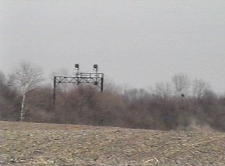 From
about a mile away, the RX signal bridge is easy to spot when the fields
are empty. From
about a mile away, the RX signal bridge is easy to spot when the fields
are empty. |
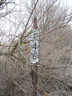
The Erie Lackawanna crossed State Road 15 in a flat open area about a mile south of the State Road 114 intersection. There were two separate concrete bridges across this road and both bridges were at different heights. The road made a slight dip to go under these bridges. Today the dip has been filled in and State Road 15 runs past this area with little heed to the remains of the EL mainline. From atop the bevel next to State Road 15, this is looking west on the EL westbound main. Some ballast, a few telegraph poles, and milepost M150 acting as a tombstone are signs that trains once passed through here. The eastbound main was to the left and was slightly lower. I often wonder what it was like as a passenger speeding through here on the Lake Cities. It must have been some sight riding way up on this high bevel looking out across the Indiana flatlands. This was taken in August 1992. (50K photo) Now looking east across State Road 15. The entire east and westbound portion of the right-of-way east of the road has been excavated and is used for farming. A careful eye is required to spot the mainline east of here, especially during the summer months. (43K photo) Taken 1/25/01. |
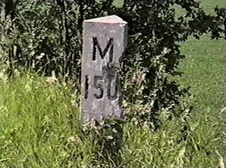 A close
up of M150 which stands way up on the high westbound main. You'll
have to do a little climbing to get to this one. A close
up of M150 which stands way up on the high westbound main. You'll
have to do a little climbing to get to this one. |
|
|
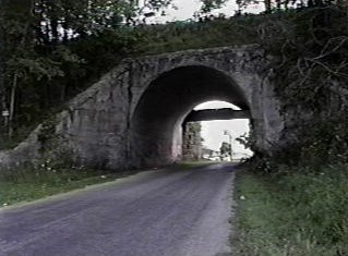 One
mile east of Disko at CR 700W are these bridges. The concrete-arch
bridge is the former westbound main and the one behind was for the eastbound
main. One
mile east of Disko at CR 700W are these bridges. The concrete-arch
bridge is the former westbound main and the one behind was for the eastbound
main. |
![]()
© Original Content Copyright 1999-2007
David Safdy
© Design and Updates Copyright 2005-2007
Greg Lavoie
Contacts
Disclaimer


