|
Erie Lackawanna - Adams County |
|||||||||||||||
|
|||||||||||||||
|
Erie Lackawanna - Adams County |
|||||||||||||||
|
|||||||||||||||
 |
 |
|
|
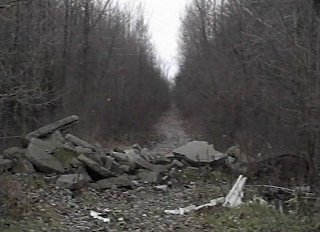 Looking
westward on the EL right-of-way at County Road 375E, just west of Rivare.
A narrow trail has been blazed through the tall trees which are swallowing
up the right-of-way. The pile of broken-up asphalt is likely the
remnants of the one time grade crossing. Looking
westward on the EL right-of-way at County Road 375E, just west of Rivare.
A narrow trail has been blazed through the tall trees which are swallowing
up the right-of-way. The pile of broken-up asphalt is likely the
remnants of the one time grade crossing. |
 The
Erie Lackawanna crossed Piqua Rd. at grade. Here we are looking west
down the right-of-way and one telegraph pole remains on the north side
of the EL path. The
Erie Lackawanna crossed Piqua Rd. at grade. Here we are looking west
down the right-of-way and one telegraph pole remains on the north side
of the EL path. |
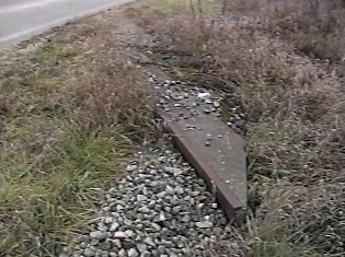 Interestingly
at Piqua Rd. are the concrete remnants of the grade crossing on both sides
of the road. Interestingly
at Piqua Rd. are the concrete remnants of the grade crossing on both sides
of the road. |
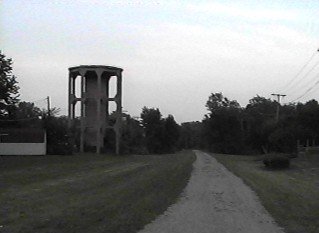 At
Mercer Ave. (old US 33) in Decatur, this is part of the Kekionga Pathway
trail down the EL right-of-way looking east. To the left is an old
concrete water tower base, similar to the one in Rochester, Indiana.
The path leads to the twin bridges across the St. Mary's River (see below). At
Mercer Ave. (old US 33) in Decatur, this is part of the Kekionga Pathway
trail down the EL right-of-way looking east. To the left is an old
concrete water tower base, similar to the one in Rochester, Indiana.
The path leads to the twin bridges across the St. Mary's River (see below). |
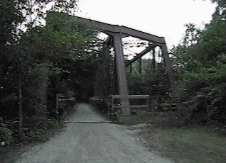 The
pathway continues through the former westbound bridge which is being quickly
consumed by trees and other shrubbery. The
pathway continues through the former westbound bridge which is being quickly
consumed by trees and other shrubbery. |
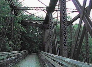 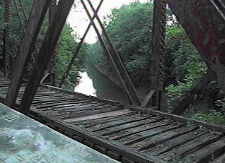
Pretty creepy.....imagine the NY-100 piggyback train coming through this bridge now. This trail is not too safe to walk on as it is very secluded and not heavily traveled. |
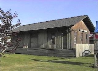 Here
is the Erie Lackawanna freight depot at Winchester St. which survives as
a storage building for the Arnold Lumber Co. The tracks were directly
in front of the station in this picture. Here
is the Erie Lackawanna freight depot at Winchester St. which survives as
a storage building for the Arnold Lumber Co. The tracks were directly
in front of the station in this picture. |
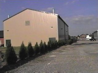 Looking
east down the EL right-of-way you can see the freight depot in the distance.
The large building on the left houses the gymnasium for the Decatur Boys
& Girls club and was built halfway across the EL main. The passenger
station was near the left side of this building. Interestingly, this building
is painted in Erie structure colors. Coincidence? Looking
east down the EL right-of-way you can see the freight depot in the distance.
The large building on the left houses the gymnasium for the Decatur Boys
& Girls club and was built halfway across the EL main. The passenger
station was near the left side of this building. Interestingly, this building
is painted in Erie structure colors. Coincidence? |
 A
pile of bricks leftover from the old brick platform that once ran alongside
the EL mains at the Decatur passenger station. This platform was
torn up along with the passenger station. A
pile of bricks leftover from the old brick platform that once ran alongside
the EL mains at the Decatur passenger station. This platform was
torn up along with the passenger station. |
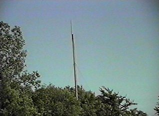 Amazingly
this is the antenna from DA Tower which guarded the EL/PC diamonds at Decatur.
The tower no longer stands today, but this amazing relic is still here
today. What frequency did it (and the EL) transmit on in Indiana?
161.400 MHz was the main frequency and no you won't hear anything on it
these days! Amazingly
this is the antenna from DA Tower which guarded the EL/PC diamonds at Decatur.
The tower no longer stands today, but this amazing relic is still here
today. What frequency did it (and the EL) transmit on in Indiana?
161.400 MHz was the main frequency and no you won't hear anything on it
these days! |
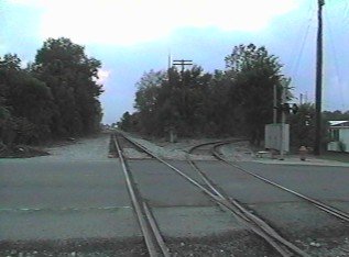 Looking
west on the former EL westbound main at Line St. near DA Tower in Decatur.
The track veering off to the right is the connection to the GR&I which
is used by the CFER to get on the Erie Lackawanna trackage. You can
see the above antenna mast to the left of the telegraph pole. Looking
west on the former EL westbound main at Line St. near DA Tower in Decatur.
The track veering off to the right is the connection to the GR&I which
is used by the CFER to get on the Erie Lackawanna trackage. You can
see the above antenna mast to the left of the telegraph pole. |
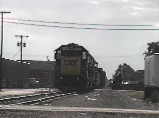 Mimicking the past is C721, the old CSX Fort Wayne to Decatur local, backing up westbound on the EL eastbound main towards the US 27 crossing in Decatur, Indiana. The only things missing here are the westbound main (to the right) and the attractive maroon, grey, and yellow paint on the locomotives. July 18, 2000. |
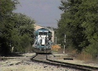 The
light engines are now returning east, now on the EL westbound main at DA
Tower. This is facing east. The tan building in the distance
behind the engines is the gymnasium of the Decatur Boys & Girls Club
and, as you can see, sits atop the northern half of the EL right-of-way.
The track the engines are on used to go through the spot where the gym
sits. The
light engines are now returning east, now on the EL westbound main at DA
Tower. This is facing east. The tan building in the distance
behind the engines is the gymnasium of the Decatur Boys & Girls Club
and, as you can see, sits atop the northern half of the EL right-of-way.
The track the engines are on used to go through the spot where the gym
sits.
July 18, 2000. |
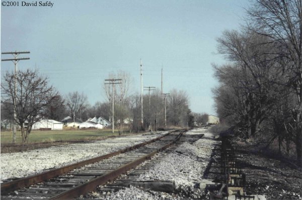
DA Tower in Decatur controlled the crossing diamonds with the Penn Central GR&I line, as well as a set of crossovers on either side of the diamonds. The tower burned down many years ago. Conrail took over this portion of the line for access to a local shipper after the Penn Central. RailAmerica's CFE now uses this segment and usage is fairly often. Looking eastward on the EL at DA Tower. You can see several of the pull-rod supports for the signals and crossovers still remain on the right. In the distance is the radio tower once used by operators at DA. It is just to the left of the 4th telegraph pole from the left. The track in the foreground is the former eastbound main. It then curves into the former westbound main. This location was the west crossover. In the distance the track ends just west of the Decatur Boys & Girls Club gymnasium, which is built atop the northern 1/2 of the Erie Lackawanna right of way. (56K photo). Taken 2/11/01. |
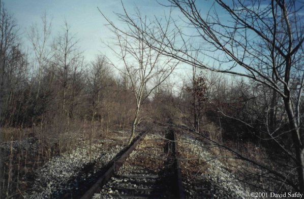
Between W. Monroe St. and Industrial Park Rd. are two disconnected segments of the EL eastbound main. Neither segment is connected to the currently used portion. A sad view facing eastward near W. Monroe St. It's hard to imagine a train passing on this today. Some of the trees growing on the tracks here are almost as thick as a telephone pole! (70K photo). Taken 2/11/01. |
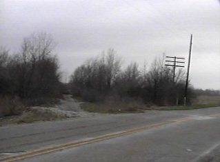
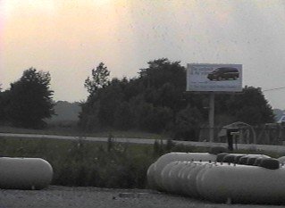 The
Erie Lackawanna crossed US 224 west of Decatur right near County Road 200W.
This is standing atop the right-of-way looking west at US 224. The
tracks were to the left of the billboard. There is one telegraph
pole still standing in the huge clump of trees which now occupy the EL
mains. Hoosier Propane, whose tanks are in this picture, is built
on the right-of-way. The
Erie Lackawanna crossed US 224 west of Decatur right near County Road 200W.
This is standing atop the right-of-way looking west at US 224. The
tracks were to the left of the billboard. There is one telegraph
pole still standing in the huge clump of trees which now occupy the EL
mains. Hoosier Propane, whose tanks are in this picture, is built
on the right-of-way. |
As a comparison of this location, check out these two photos on George
Elwood's Fallen Flags site, taken by himself in 1965:
http://www.rr-fallenflags.org/el/loco/pa-xing1.jpg
- Eastbound freight with PA's approaches US 224, approximately where the
billboard sign is above.
http://www.rr-fallenflags.org/el/loco/pa-xing2.jpg
- Looking the other way, the train is passing through what is now Hoosier
Propane.
Looking at the site of this former crossing today it's hard to believe
anything went through here, let alone two Alco PA beauties.
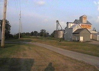 This is
at County Road 400W in Preble, Indiana. We are looking directly east
on the right-of-way which passed to the left of the co-op elevator.
One lone telegraph pole remains far in the distance. This is
at County Road 400W in Preble, Indiana. We are looking directly east
on the right-of-way which passed to the left of the co-op elevator.
One lone telegraph pole remains far in the distance. |
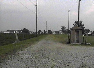 On the
west side of Preble is Firemen's Park. If you enter the park from
CR 450W you'll drive on top of the Erie Lackawanna roadbed. Near
the baseball diamond is an Erie concrete telephone shanty and to the left
is a concrete whistle post. On the
west side of Preble is Firemen's Park. If you enter the park from
CR 450W you'll drive on top of the Erie Lackawanna roadbed. Near
the baseball diamond is an Erie concrete telephone shanty and to the left
is a concrete whistle post. |
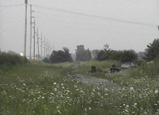 At Adams
County Road 600W, which passes through Magley, Indiana this is looking
east down the Erie Lackawanna. The tracks were to the right of the
tall line of utility poles. There are just about no signs of the
EL here except for a slight hump in the road where the tracks used to cross. At Adams
County Road 600W, which passes through Magley, Indiana this is looking
east down the Erie Lackawanna. The tracks were to the right of the
tall line of utility poles. There are just about no signs of the
EL here except for a slight hump in the road where the tracks used to cross. |
![]()
© Original Content Copyright 1999-2007
David Safdy
© Design and Updates Copyright 2005-2007
Greg Lavoie
Contacts
Disclaimer


